US Highway 17A (Boone Hill Road)
Project Description
US Highway 17A (Boone Hill Road) Project proposes to widen and improve associated intersections on US 17A for approximately 6.6 miles between Research Center Drive and Luden Drive to reduce traffic congestion, improve safety, and accommodate bicyclists and pedestrians.
Announcements
The blue outline on the map indicates the general vicinity for the transportation project. The boundary is for informational purposes only and does NOT indicate property impacts.
Proposed Road Sections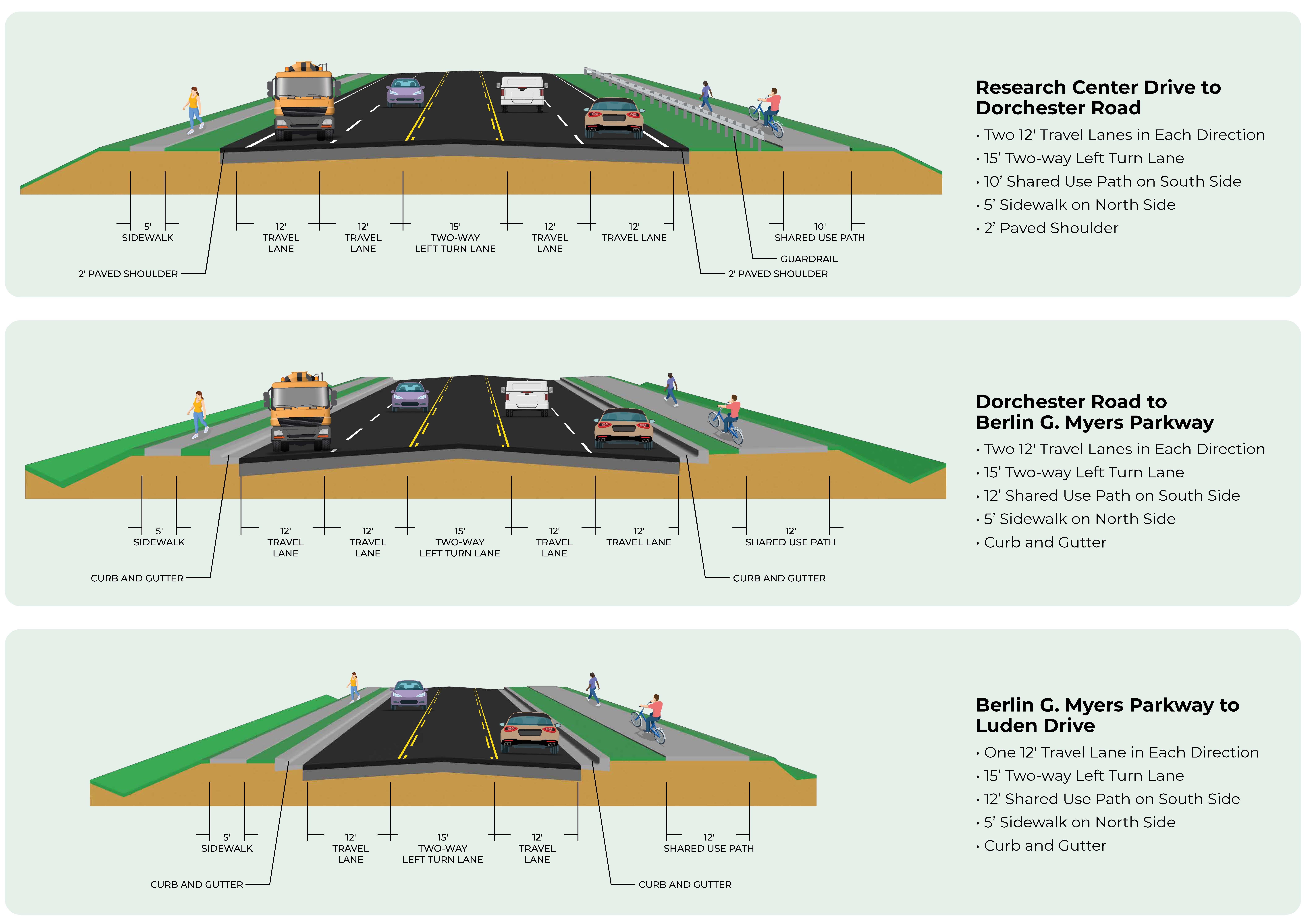
Dashboard
The embedded Power BI Dashboards can be viewed in full screen by clicking the arrow  on the bottom right of the BI Dashboard. Press ESC to exit full screen and return to the Home page.
Project Announcements
Dorchester County held a public meeting Thursday, July 16th from 5:30 p.m. to 7:30 p.m., at Summerville High School, 1101 Boone Hill Road, Summerville, SC 29483.
The meeting was a drop-in format, and no formal presentation was given. The purpose of this meeting was to provide information about the project, share preliminary plans, and to solicit the public’s feedback. The US Highway 17A Improvements Project includes the widening of US Highway 17A between Research Center Drive and Luden Drive and improve associated intersections along the corridor to reduce future traffic congestion, improve safety, and accommodate bicyclists and pedestrians.
Comments from the public were accepted for a 30-day period following the public meeting. To access meeting materials and the online comment form after the in-person meeting, please visit DorchesterTransportation.com or email Transportation@dorchestercountysc.gov.
Environmental & Community Resources
Alternatives Impacts Comparison
NOTICE TO CITIZENS OF DORCHESTER COUNTY: Pursuant to the South Carolina Eminent Domain Procedure Act, Section 28-2-70(c), Code of Laws of South Carolina, 1976, as amended, notice is hereby given that entry by personnel of, or working under contract with, Dorchester County (County) will be made in the area of the road(s) described below for such purposes as topographic surveys, subsurface exploration, environmental related studies and for the gathering of any other data necessary for the planning, design, property acquisition and construction of a roadway improvement project. Surveys for the project will be conducted on the following road(s) as described:
- US Highway 17A (Boone Hill Road) between Research Center Drive and Luden Drive, including up to 300 feet in either direction on most intersecting roadways
- Up to 2000 feet in either direction on the following roadways intersecting US Highway 17A: SC Highway 61, Beech Hill Road, Summers Drive, SC 642 (Dorchester Road), S-13 (Central Avenue), S-22 (Orangeburg Road), Tupperway Drive, and Luden Drive.
The project involves road widening and intersection improvements, and improvements to bicycle and pedestrian accommodations. This project is made possible by the Dorchester County Transportation Sales Tax Program. Information about the project may be obtained by contacting Dorchester County at Transportation@dorchestercountysc.gov or visiting https://dorchestertransportation.com/. Dorchester County Project ID: 24TS17
NOTICE TO CITIZENS OF DORCHESTER COUNTY: Pursuant to the South Carolina Eminent Domain Procedure Act, Section 28-2-70(c), Code of Laws of South Carolina, 1976, as amended, notice is hereby given that entry by personnel of, or working under contract with, Dorchester County (County) will be made in the area of the road(s) described below for such purposes as topographic surveys, subsurface exploration, environmental related studies and for the gathering of any other data necessary for the planning, design, property acquisition and construction of a roadway improvement project. Surveys for the project will be conducted on the following road(s) as described:
- US Highway 17A (Boone Hill Road) between Research Center Drive and Greenwave Boulevard, including up to 300 feet in either direction on most intersecting roadways
- Up to 2000 feet in either direction on the following roadways intersecting US Highway 17A: SC Highway 61, Beech Hill Road, Summers Drive, SC 642 (Dorchester Road), S-13 (Central Avenue), S-22 (Orangeburg Road), and Tupperway Drive
The project involves road widening and intersection improvements, and improvements to bicycle and pedestrian accommodations. This project is made possible by the Dorchester County Transportation Sales Tax Program. Information about the project may be obtained by contacting Dorchester County at Transportation@dorchestercountysc.gov or visiting https://dorchestertransportation.com/. Dorchester County Project ID: 24TS17
Project Fast Facts
The Program’s project list was developed through a collaborative effort led by an Infrastructure Subcommittee, which was specifically formed for the Transportation Sales Tax (TST) initiative. This subcommittee brought together local leaders, planners, engineers, and elected officials, including representatives from Dorchester County government, the Town of Summerville, City of North Charleston, and the Greater Summerville/Dorchester County Chamber of Commerce. Working in coordination with the Berkeley-Charleston-Dorchester Council of Governments (BCDCOG), Berkeley County, and Charleston County, the committee aimed to identify and prioritize transportation projects that addressed critical infrastructure needs throughout the County.
The Infrastructure Subcommittee provided a recommended list of projects to Dorchester County Council, which reviewed the proposed transportation projects for alignment with the County’s Comprehensive Plan, Strategic Plan, and infrastructure priorities. A public hearing was held on September 19, 2022, and the public’s feedback was used to further refine the list of projects, which were ultimately approved by Dorchester County Council through Ordinances 22-16 and 22-22 to levy and impose a one percent sales and use tax, subject to a referendum. On November 8, 2022, Dorchester County voters favored continuing the existing sales and use tax.
- The original project limits for US Hwy 17A Improvements extended from Greenwave Boulevard to the proposed future Glenn McConnell Parkway Extension, which was subsequently removed from the 2022 Transportation Sales Tax Referendum. The project limit was then shifted to Research Center Drive as the nearest existing crossroad that provides a logical terminus for the project.
- The northern project limit was extended to Luden Drive following the opening of Berlin G. Myers in 2025 due to increased traffic on Luden Drive.
- Extending the project limits to Colleton County would not be feasible at this point in time since Colleton County does not have an adjacent project that Dorchester County could tie into.
The project will reduce future traffic congestion, improve safety, and accommodate bicyclists and pedestrians throughout the corridor. Click on the buttons below to explore more about each safety element.
No. The 2022 Transportation Sales Tax program will generate $700 Million in funding for transportation improvements, but the funding needs for the Program’s projects well exceed that. While US HWY 17A (Boone Hill Road) is identified as a corridor with considerable growth projected, the County must prioritize our projects based on current needs and available funding. US HWY 17A Improvements are currently only funded through preliminary design, but it will be developed to remain eligible for Federal grants and other funding and partnership opportunities as they become available to supplement the project cost and bridge the funding gap for project completion. By getting this project closer to ‘shovel ready’, it will allow it to score more competitively for federal funding or other grant opportunities.
- Concept plans presented at the Public Information Meeting in July 2026 show a high-level estimate of proposed improvements and future right-of-way locations. These plans are subject to change as the design is revised and as the County works to minimize impacts through further development of the engineering plans.
- As the design is further developed, right-of-way plans will need to be approved by the SCDOT. Once approved, the SCDOT will issue the County authorization to move forward with right-of-way acquisition. It is important to remember that right-of-way is not only needed for road improvements, but also other infrastructure improvements that are included in these projects such as the construction of sidewalks or shared use paths, drainage improvements, and utility relocations.
If right-of-way needs to be obtained from your property due to a transportation improvement project, a right‑of‑way agent contracted through Dorchester County will contact you directly to explain the formal process and next steps at that time. To learn more about your rights and available resources, you may review SCDOT’s Highways and You Brochure.
- Partial Property Acquisition (Partial Take)
Portions of private properties (typically referred to as strip takes) may need to be acquired in order to construct and maintain the transportation project. This area could be used for widening, drainage, or utility improvements and could be purchased as an easement or in Fee Simple. In these situations, you will receive compensation both for the land acquired and for any impacts to the remaining property, if applicable. When this occurs, the right‑of‑way agent will make an offer for the fair market value of the property based on an appraisal. The right‑of‑way agent will review the appraisal with you and explain how the value was determined. If adjustments to driveways, landscaping, or access are required, the project team will work with you to minimize disruptions.
- Full Property Acquisition (Full Take)
In some cases, a transportation project may require the purchase of an entire property. When this occurs, the right‑of‑way agent will make an offer for the fair market value of the property based on an appraisal. If relocation is necessary, residents are eligible for relocation assistance benefits such as help finding a new home, reimbursement for closing costs, moving costs, and, when applicable, supplemental payments to ensure access to comparable replacement housing. All services are provided at no cost to the property owner or tenant, and the goal is to make the transition as smooth and equitable as possible. Any resident who must relocate due to a Transportation Sales Tax project is protected under the Uniform Relocation Assistance and Real Property Acquisition Policies Act of 1970, as amended (42 U.S.C. 4601 et seq.). These federal protections guarantee fair and consistent treatment, just compensation, and assistance during the moving and relocation process.
- Dorchester County’s Zoning and Land Development Standards 04-13, Section 5.4.8 (Setbacks from Designated Corridors) requires developments to be constructed with setbacks and buffer yards measured from the future right-of-way established for designated transportation projects such as US HWY 17A (Boone Hill Road)
- All new developments must follow the County’s Traffic Impact Analysis (TIA) program that was passed by County Council in 2018. (Ordinance 18-05). This program holds all developers responsible for addressing the impact of their developments and ensure that improvements are completed in a timely manner. The TIA program requires new developments (including additional phases of development) to complete traffic studies and mitigate their own impacts, on and off site, to ensure there are adequate roads as growth occurs.
Further, as more developers look to build along the corridor, this TIA program may trigger roadway improvements to be constructed as part of each development prior to the construction of 17A Improvements and/or require the developers to provide funding contribution to the County to contribute towards the 17A Improvements project.
For more information on the TIA program:
Yes. The project will follow the National Environmental Policy Act (NEPA) to assess the environmental effects of the proposed project prior to making decisions. Using the NEPA process, agencies evaluate the environmental and related social and economic effects of their proposed actions. This also includes opportunities for public review and comment on these evaluations.
- All Federal-aid projects and/or projects with the need for Federal-permitting must comply and adhere to the NEPA. The lengthy NEPA process requires the completion of the following:
- Public Information Meetings
- Technical Studies (18): Air Quality, Architectural/Archaeological, Endangered Species, Wetlands, etc.
- Development of Alternatives
- Analyze Alternatives
- Preparation of a draft Environmental Assessment
- A Public Hearing
- Federal Highway Administration (FHWA) decision
- For more information on NEPA: https://www.epa.gov/nepa/what-national-environmental-policy-act
- In 2025, County Council passed Ordinance 25-15 for compensatory storage. This ordinance was passed to ensure upstream and downstream properties are not negatively impacted by new development within the floodplain.
- For more information on Ordinance 25-15: https://www.dorchestercountysc.gov/government/county-council/ordinances-resolutions/2025-ordinances#docaccess-19ff2e2495a766cb91e0926ac8697325
Throughghout the entire life of a project, construction is typically the shortest phase of the project. Prior to construction, the project must go through strict environmental reviews, permitting, right-of-way acquisition, utility relocation, and overall coordination with the community. Many of these phases in the project can take several years to coordinate and work through.
No. The SCDOT Rural Road Safety Program recently completed improvements to this corridor to reduce the frequency of fatal and serious injury crashes occurring on this roadway. These safety improvement projects can include various engineering solutions such as widening and paving of the shoulders, wider and brighter pavement markings, edge line and centerline rumble strips, right-of-way clearing to improve clear-zone visibility, flattening of roadside slopes and additional guardrail to reduce the frequency of fatal and serious injury run-off-the-road crashes. Since this project is still several years away from construction, the SCDOT determined it would be beneficial to move forward with these critical road safety improvements. As always, Dorchester County works closely with the SCDOT to coordinate these projects as this corridor is a State maintained roadway.
For more information on Google Data Center: https://www.dorchestercountysc.gov/business/data-center-fact-sheet
- The project team follows the procedures of the South Carolina Department of Transportation (SCDOT) Traffic Noise Abatement Policy, which was developed to meet Federal Highway Administration (FHWA) requirements.
- As a part of the preliminary design development process for this project, a traffic noise impact analysis was completed to study the existing noise levels and future projected noise levels along the entire corridor. The purpose of the analysis is to evaluate whether noise abatement measures need to be considered as part of the project to help reduce noise impacts that would result from the project