Public Meeting #2 Summary
Main Street (US 17A)
Overview
Dorchester County hosted an online Public Information Meeting (PIM) on the project website for the Main Street Improvements Project and accepted public comments from June 15 through July 15, 2026. The first public meeting about this project was held in person on January 13, 2026, in coordination with the Town of Summerville’s adjacent Main Street Resiliency Project. Following public input from the first meeting, the County conducted a second public meeting online to provide updates on the County’s Main Street Improvements Project. The meeting was advertised with roadway signage, newspaper advertisements, promotion on County social media channels, and a postcard mailing to the area adjacent to the project. The purpose of this online meeting was to present revised roll plots, renderings, and other updates since the first PIM, highlight changes made by the County in response to public feedback, and solicit comments on the updated conceptual plans.
Main Street (US 17A) PIM #2Roll PlotsTypical Sections & Renderings
The public was invited to submit comments through the project website, by mail, or by email. A total of 47 comments were received during the comment period from June 15 through July 15, 2026.
Proposed Improvements
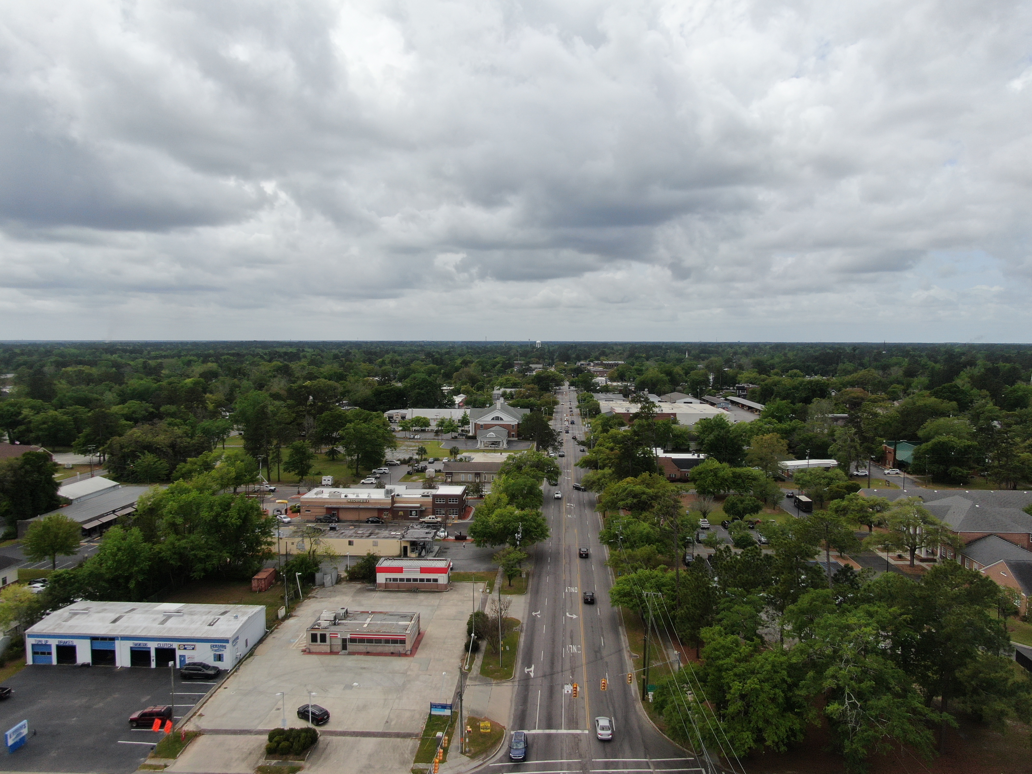
Dorchester County proposes improvements along US Highway 17A (US 17A/Main Street) from Carolina Avenue to Luke Avenue to enhance the corridor, improve pedestrian safety and operations, and provide better accommodations for pedestrians and bicyclists.
The initial proposed improvements presented at the first public meeting for the project included:
- Add 10-foot-wide shared-use path
- Provide continuous 5-foot-wide sidewalk by enhancing existing and constructing new sidewalks as needed
- Add SHARROWS (markings on road to share lanes with bikers) where shared-use path cannot be accommodated
- Add raised crosswalks
- Install curb and gutter with drainage improvements
- Add landscaped/planted, concrete, and paver/mountable medians in select locations
Design Updates
Based on feedback received during the first PIM, the County focused on addressing specific issues and aspects of the design that the community opposed while still improving bicycle and pedestrian access and safety along the corridor.
Traffic Flow & Road Design
Nearly all proposed landscaped medians have been eliminated or replaced with a raised brick median. The only proposed landscaped/planted median is included with a raised crosswalk at Azalea Park. According to the Federal Highway Administration (FHWA), raised crosswalks have been proven to increase safety by reducing pedestrian crashes by 45%. This will slow vehicles down, improve safety for pedestrians crossing Main Street, and help to maintain the park feel through Azalea Park. All raised medians being proposed include mountable curb that will allow emergency vehicles to easily drive onto the median.
Existing Pedestrian and Cyclist Accommodations & Safety
The updated design includes safer crossings, sidewalk connections, flashing beacons, and shared-use paths to help people safely get to school, Azalea Park, and Downtown Summerville. These improvements aim to encourage pedestrians to walk or bike safely through the corridor rather than getting into their vehicle. Sharrows are only incorporated for one block along Hutchinson Square, to accommodate bicycles traveling throughout the corridor without needing any additional right-of-way along the park or businesses in this area.
Environmental & Community Impact
The proposed concept is still early in the design process. As the design is advanced further, the County will work to reduce the number of impacts throughout the corridor to maintain the character of Main Street. Meandering the sidewalks around trees or narrowing down the width for short distances are examples of tools we can use to avoid impacts. If trees cannot be avoided, the County plans to mitigate with new native landscaping. This could include azaleas, crape myrtles, pine trees, sweetgrass, etc. Overall, these improvements are aimed at encouraging Main Street to be a destination corridor and encourage traffic to utilize other routes, such as Berlin G Myers, as a faster option through Summerville.
Utilities
Moving utilities underground is currently not included as part of this project. The cost to bury power lines in this area would be estimated at $1.5 million per mile[CF
Five Points (Carolina Avenue)
Improvements at the Carolina Avenue intersection are currently not included in the project scope due to the level of impact and overall opposition from residents.
Summary of Comments Received during the Online PIM #2
Most comments received were focused on identifying existing concerns or offering suggestions for improvements.
This section provides a general overview of the public comments received during the second public comment period that ended on July 15, 2026. Below are some common themes identified in the comments received as well as responses to the common questions that were raised.
Traffic Flow & Road Design
Access concerns emerged as a frequently cited theme. Approximately 28% of commenters expressed concerns about how the proposed improvements may affect daily travel, residential and business access, and overall traffic operations with the presence of raised/landscaped medians, curbs, and on-street parking.
- Raised/Landscaped Medians: Several comments expressed concerns about raised medians reducing the ability for residents or commuters to make left turns and access their properties or businesses without making a U-turn.
- This project is following SCDOT’s Access and Roadside Management Standards (ARMS) related to raised/landscaped medians. Raised and landscaped medians are proposed in limited locations that do not impact current property access. Raised/landscaped medians are intended to improve roadway safety and traffic operations by separating opposing traffic, controlling access and turning movements, providing pedestrian refuge at designated crossings, and providing traffic-calming benefits by visually narrowing the roadway and reinforcing the intended operations. Landscaping in medians can also enhance corridor aesthetics and provide stormwater management.
- Additional Resources:
SCDOT - Access Management
- On-Street Parking: Several comments expressed concerns about on-street parking, including parallel and reverse parking spaces causing overall congestion and safety concerns.
- The design balances providing additional parking for businesses and events with improving roadside safety and drainage. Reverse angle parking spaces are included in the design based on safety. The current design includes five parallel parking spaces and ten reverse angle parking spaces. The project team is also removing three parallel parking spaces to improve an existing taper to meet design standards.
- Speed Reduction: Several comments expressed concerns about speed along the corridor and recommended speed reduction measures, including speed bumps, speed checks, and additional raised crosswalks.
- The County must follow SCDOT guidelines for speed calming on state-maintained roads. Some SCDOT-approved speed-calming measures include landscaped island/medians and raised crosswalks, which are being implemented with this project.
- Turn Lanes/Center Turn Lanes: Several comments expressed concerns about the addition of turn lanes and a center turn lane, stating they were not necessary.
- Center two-way left turn lanes improve traffic operations and provide refuges for turning vehicles. Turn lanes are being implemented for this project where traffic analysis indicated that they were recommended for safety and traffic operations.
- Line of Sight/Visibility: Several comments mentioned the need for improved line of sight and visibility, specifically the need to trim tree branches around traffic signals and shrubbery that obstructs views.
- The project will be designed in accordance with SCDOT ARMS, including guidelines for maintaining sight lines. Some key requirements for removing or controlling sight obstructions include vegetation, trees, shrubs, parked vehicles, landscaping, utilities, signs, and landscaping.
Pedestrian and Cyclist Accommodations & Safety
Approximately 62% of comments focused on bike lanes, sidewalks, crosswalks, crossings, or lighting.
- Shared-Use Path and Additional Sidewalks: Some commenters expressed opposition to a shared-use path and/or more sidewalks, noting that they felt the existing facilities were sufficient. Some commenters also supported additional sidewalks.
- This project is being designed to align with Dorchester County’s Complete Streets initiative, SCDOT’s Complete Streets policy, andBerkeley-Charleston-Dorchester Council of Governments’ (BCDCOG) Walk+Bike Plan to improve multimodal connectivity and community access and provide safe and efficient transportation options for all modes of transportation. Shared-use paths provide access for all bicycle users including children riding to school and other residents, as well as walkers and runners. They enhance multimodal mobility by providing a continuous route for pedestrians and bicyclists, as well accommodating users with varying mobility needs. Bicycle and pedestrian accommodations will be further evaluated as the design develops.
- SHARROWS (shared bike lanes): Commenters had concerns about the safety of the proposed shared bike lanes near Hutchinson Square. Recommendations included making the markings larger and removing them altogether.
- SHARROWS are proposed in Hutchinson Square instead of a shared-use path, due to the constrained right-of-way in that area. The SHARROWS will be designed and implemented to standard specifications, including SCDOT Traffic Engineering Guidelines for Use of Shared Lane Pavement Marking Symbols.
- Raised Crosswalks and Other Recommended Features: Commenters supported the addition of the raised crosswalks along the corridor, and some encouraged the addition of more. Additional pedestrian/cyclist safety measures were suggested, including:
- Adding American Disabilities Act (ADA) aids or audio prompts at crosswalks/intersection
- Adding pedestrian crossing signage
- Enhanced lighting at intersections and crosswalks
- The County is committed to providing safe and accessible accommodations for all road users. Additional features to enhance these accommodations will be evaluated with detailed design. Most features such as crosswalks and/or signage require approval by SCDOT for state-maintained roads.
- Additional Resources:
- Dorchester County – Complete Streets Ordinance
Five Points (Carolina Avenue)
Approximately 11% of comments expressed the desire for the Five Points area (Carolina Avenue) to be improved, including adding a roundabout at the intersection, providing crosswalks, and extending sidewalks to and/or along Carolina Avenue.
- The Five Points area is not included in this project’s scope due to anticipated impacts and community feedback. In response to resident input from the first public meeting, the project scope has been adjusted to not include improvements between Carolina Avenue and Richland Street.
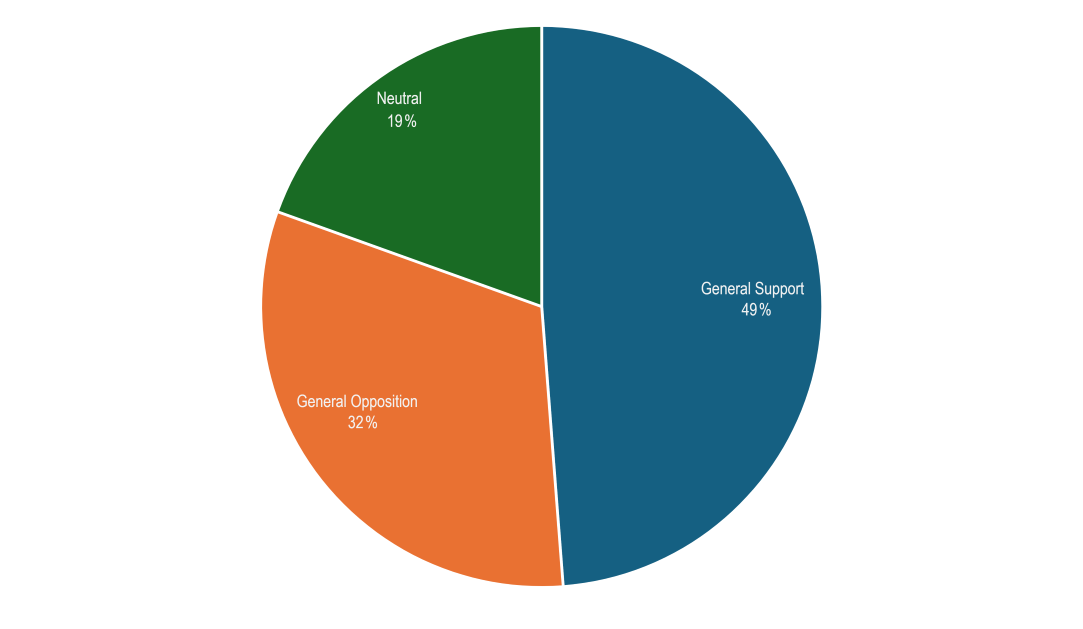
Overall Summary
- Approximately 49% of the comments were in general support of the project as presented.
- Approximately 32% of the comments were in general opposition to the project as presented at the public information meeting.
- Approximately 19% of commenters were neutral about the project as presented.