Public Meeting #1 Summary
Central Avenue & Parsons Road Improvements
Public Meeting Summary
Overview
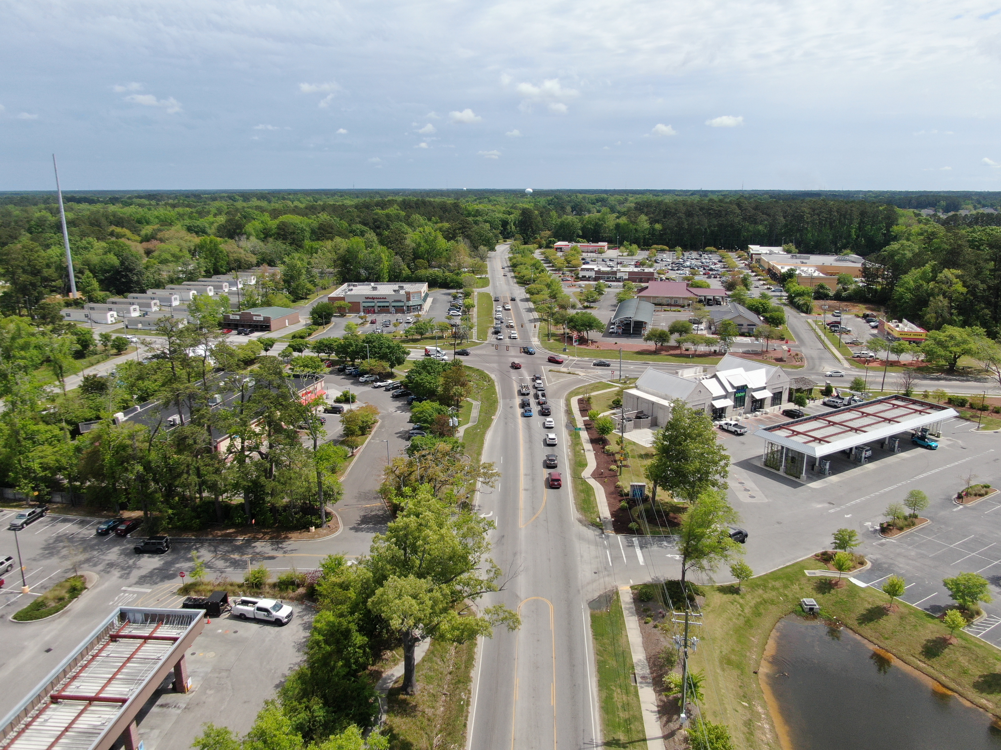
An in-person Public Information Meeting (PIM) was held for the Central Avenue and Parsons Road Improvements Projects on June 10, 2025, from 5 -7 PM at the Alston-Bailey Elementary School in Summerville, South Carolina. In addition, project specific websites were hosted on Dorchester County’s website, allowing individuals to review the public meeting materials and provide input at their convenience, thereby expanding access for those unable to attend in person.
Upon arrival, attendees were asked to sign in and received a project handout outlining the project purpose, proposed improvements, anticipated schedule, and instructions for submitting comments. Dorchester County staff and project representatives were stationed throughout the meeting room. Nine display boards were arranged in stations around the perimeter of the room, showcasing the project location, environmental and community resources, project development process and schedule, project improvements, existing and future traffic, and concept alternatives. In addition, roll plots were displayed showcasing the design alternatives. Use the buttons below to review meeting materials.
Handout Background Environmental & Community Resources Traffic Data
Typical Sections Alternative 1 Roll Plot Alternative 2 Roll Plot
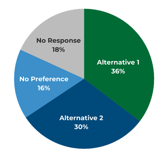
The public was invited to submit comments or questions via the project website, mail, email, or in person at the PIM. A total of 110 comments were received during the comment period from June 10, 2025, through July 10, 2025. Of those, 36% expressed a preference for Alternative 1, 30% preferred Alternative 2, 16% had no preference, and 18% did not respond to the question.
Central Avenue Improvements
Dorchester County proposes roadway widening and improvements along Central Avenue from Orangeburg Road to Parsons Road. The Project Study Area extends along Central Avenue for approximately 2.8 miles through the Town of Summerville, SC. Two alternatives are being evaluated for Central Avenue to include the following:
- Alternative 1: 3-Lanes from Orangeburg Rd to W Butternut Rd & 5-Lanes from W Butternut Rd to Parsons Rd.
- Alternative 2: 5-Lanes from Orangeburg Rd to Parsons Rd.
The proposed roadway sections will also include curb and gutter, enclosed drainage, shared use path, sidewalk, and associated improvements.
Parsons Road Improvements
Dorchester County proposes roadway widening and improvements along Parsons Road from Central Avenue to West Richardson Avenue. The Project Study Area extends along Parsons Rd for approximately 1.37 miles through the Town of Summerville, SC. One 3-lane alternative is being evaluated. The proposed roadway section will also include curb and gutter, shared use path, sidewalk, enclosed drainage, and associated improvements.
Summary of Public Comments Received
This section provides a summary of the public comments received during the public comment period from June 10 to July 10, 2025.
Central Avenue Alternative 1 (3-Lane/5-Lane)
Support
- Property Impacts - Preserves more private property, trees, and neighborhood character.
- Safety - Fewer lanes may help discourage speeding.
Concerns
- Limited Capacity – May not support long-term traffic growth from continued development in the area.
- Short-Term Fix – Viewed as a temporary solution that could require future additional widening.
Central Avenue Alternative 2 (5-Lane)
Support
- Long-Term Solution – Designed to accommodate projected traffic volumes over time.
- Increased Capacity –Expected to reduce congestion at key intersections.
Concerns
- Property Impacts – Requires more right-of-way, resulting in greater impacts to private property.
- Safety & Noise – Wider roadway may encourage higher speeds; proximity to homes could lead to increased traffic noise.
Traffic Congestion & Intersection Improvements
Residents consistently voiced concerns about congestion and safety at key intersections throughout the corridor, particularly in areas experiencing rapid development.
- Intersections: Frequent backups were reported at Orangeburg Road, Parsons Road, and Butternut Road, especially during peak commuting hours.
- Turn Lanes: Many comments supported the addition or extension of left and right turn lanes to improve traffic flow and reduce delays.
- Signalization Needs: Community members repeatedly identified White Gables Drive, Woodward Boulevard, and Mt. McKinley Drive as intersections in need of traffic signals to address safety and congestion concerns.
- Roundabout Feedback: Opinions on roundabouts were mixed. Some residents supported them for improving flow and reducing crashes, while others cited confusion, safety risks, and concerns over property impacts.
Shared Use Path
- Shared Use Path: Many commenters supported sidewalks and shared use paths, especially in areas near neighborhoods, to enhance active transportation options and improve overall connectivity.
- Bike Infrastructure: Some commenters expressed interest in dedicated bike lanes, in addition to shared use paths and their connectivity to adjacent existing infrastructure.
- Proximity to Homes: Some residents voiced concern about sidewalks and paths being located too close to private residences.
Safety
Safety was a frequent concern, particularly at intersections and regarding pedestrian access.
- Parsons Road: Multiple residents raised concerns about the sharp curve on Parsons Road, suggesting realignment or improved visibility to enhance safety.
- Pedestrian Safety: Many comments highlighted the need for safer pedestrian crossings and increased visibility for walkers.
- Speed Management: Residents requested enhanced speed enforcement, installation of radar speed signs, and other traffic calming measures.
- Lighting & Visibility: Numerous comments emphasized the importance of improved lighting to reduce nighttime crashes and enhance overall safety.
- Emergency Access During Construction: Several commenters expressed concerns about maintaining access for emergency vehicles and potential delays to emergency response during construction.
Drainage & Flooding
- Flood-Prone Areas: Parsons Road and several other low-lying areas experience recurring flooding.
- Stormwater Infrastructure: Many comments requested upgrades to drainage systems, including culvert improvements and the use of sustainable stormwater management practices.
Environmental
- Tree Preservation: Many commenters voiced strong opposition to the removal of mature and historic trees, particularly Live Oaks.
- Green Buffers: Desire to maintain landscaping and minimize excessive paving to help preserve the corridor’s natural character.
Noise
- Construction Noise: Concerns about disruption to daily life during construction, with requests for clear construction schedules and efforts to minimize impacts.
- Post-Construction Noise: Concerns that road widening will increase noise near residential areas.
- Mitigation Requests: Suggestions for noise-reducing barriers and landscaped buffers to lessen impacts.
Utilities
- Power Lines: Some commenters asked whether existing overhead power lines would be relocated underground.
- Sewer Lines: Questions were raised about the installation or extension of sewer infrastructure throughout the project corridor.
Right of Way
- Property Impacts: Residents asked for clarity on which properties would be affected and how much.
- Communication: Residents requested early communication and fair compensation.
Frequently Asked Questions
General
- Alternative 1 includes widening to 3 Lanes from Orangeburg Rd to W Butternut Rd and widening to 5 Lanes from W Butternut Rd to Parsons Rd.
- Alternative 2 includes widening to 5 Lanes from Orangeburg Rd to Parsons Rd.
- Both alternatives include curb and gutter, enclosed drainage, a 12-foot shared use path, a 5-foot sidewalk, and associated improvements.
- Central Avenue Improvements – construction is anticipated to begin in early 2029 and take approximately 3 years to complete.
- Parsons Road Improvements – construction is anticipated to begin mid-2028 and take approximately 2.5 years to complete.
- Residents and businesses will be notified of major changes, or disruptions through general project communications, public notices, and/or posted signage. Construction phasing and traffic impacts will be shared in advance to help minimize disruption.
- Daytime road closures are not anticipated at major intersections such as Central Avenue at Orangeburg Roadway, Old Parsonage Road, West Butternut Road and Parsons Road, and Parsons Road at West Richardson Avenue.
- The general project limits were identified during development of the Dorchester County Transportation Sales Tax referendum and further refined through completion of the project-specific traffic study and conceptual design alternatives.
- Widening Central Avenue from Orangeburg Road to US Highway 17A is not included with the project scope and was not identified as a project under the current Sales Tax Program; however, it may be considered for future programs.
Traffic Congestion
- Yes. The traffic analysis shows that without improvements, key intersections, including Orangeburg Road at Central Avenue, Butternut Road at Central Avenue, and Parsons Road at Central Avenue, are projected to exceed their capacity and operate in failing conditions by 2050. See table of Traffic Data here: https://dorchestertransportation.com/application/files/8617/4957/4822/Traffic_Data.pdf
- All alternatives being considered are designed to improve traffic flow and are expected to enhance performance at major intersections within the project area.
Intersection Improvements
- The decision to propose a roundabout or a traffic signal is based on traffic volume, safety, delay reduction, and long-term operational efficiency.
- Roundabouts have been shown to significantly reduce serious injury crashes, improve intersection efficiency during peak hours, and accommodate continuous movement, especially in congested corridors.
- A traffic signal was evaluated as an alternative to the roundabout but did not meet signal warrant criteria as established by the SCDOT. As a result, a roundabout was presented as an alternative to the current stop-controlled intersection.
- The stop-controlled alternative would function similar to the existing White Gables Drive intersection, allowing left turns both into and out of the subdivision. This alternative also includes a new left-turn lane onto Carroway Drive, improving upon current conditions. Both roundabout alternatives would maintain all existing turning movements at the intersection.
- The improvements at Pinewood Drive are needed due to the reconfiguration and added turn lanes on the Parsons Road side of the intersection. To align with the new Parsons Road lanes, the through lanes must be shifted. This shift also creates space for a dedicated left-turn lane, which will help improve traffic flow and overall operations at the intersection.
- While a traffic signal was not warranted based on the traffic study, turn lane improvements are proposed to address safety and access concerns.
- A northbound left-turn lane and a southbound right-turn lane are proposed on Parsons Road to improve turning movements onto Mt McKinley Drive and support safer access into and out of the Summit neighborhood.
- While a traffic signal was not warranted based on the traffic study, turn lane improvements are proposed to improve traffic flow and safety concerns at the following locations:
- an eastbound left-turn lane from Central Avenue onto Henry Myers Boulevard
- an eastbound right-turn lane from Central Avenue onto Woodward Boulevard
- a westbound left-turn lane from Central Avenue onto Woodward Boulevard
Shared Use Path (SUP)
- A SUP is an off-street facility designed for both bicyclists and pedestrians, offering a wide, physically separated space that supports two-way, non-motorized travel.
- A dedicated bike lane is an on-street facility designed for bicycle use only. It typically runs in the same direction as vehicle traffic and is separated by paint or flexible posts.
- Dedicated bike lanes are not included in this project.
- The typical section and the placement of the SUP on one side of the roadway was recommended during project development to balance impacts to adjacent properties, limit number of driveway crossings, improve safety, and enhance bike and pedestrian connectivity. Typically, the preference is to keep the SUP on one side of the roadway to encourage recreational users on one side and intermittent connectivity of pedestrians via a sidewalk on the other side. The SUP on one side of the road also simplifies crossings at signalized intersections, has fewer conflicts at driveways, and minimizes impacts to residential homes and other roadside features. The design of these facilities is currently being re-evaluated and may be refined in response to feedback received.
- No. SUPs are designed for non-motorized users such as pedestrians and bicyclists. ATVs, golf carts, and other motorized vehicles are not permitted.
Safety
- The proposed posted 40 mph speed limit signage on Central Avenue will match existing conditions. On Parsons Road, the current posted speed limit is 45 mph, with a reduction to 35 mph approaching the West Richardson Avenue intersection. The proposed posted speed limit will be reduced to 40 mph and will maintain the 35 mph posted speed approaching the West Richardson Avenue intersection.
- Safety improvements include:
- Dedicated turn lanes to reduce rear-end collisions.
- Design includes a curb and gutter on the outside that has a tendency to slow traffic compared to the open shoulder condition that exists today.
- Address clear zone along the corridor by removing obstructions within 16 feet of the travel way and providing clear sight lines when turning right and left from sideroads.
- We are making slight adjustments to the roadway curvature when appropriate to ensure compliance with clear zone requirements.
- The project team will coordinate closely with local emergency services throughout construction to ensure that emergency access is maintained at all times.
- Construction phasing and detours will be planned to minimize disruptions to response times and critical access routes.
- The proposed design for Parsons Road does realign the roadway to flatten or increase the curve radius for the two curves along the corridor. By flattening the curves, motorists will have better visibility through the curves and safer conditions.
- The Central Avenue and US 17A. intersection is outside the limits of the current Dorchester County project. However, the South Carolina Department of Transportation (SCDOT) is planning safety improvements at this intersection. A roundabout is proposed as part of that project; additional information is available on SCDOT’s project portal: https://projectportal.scdot.org/17ARoundabout.
Drainage & Flooding
- Yes. The project assesses existing flooding and will address stormwater conveyance within the right-of-way to include new grading to channel offsite surface waters to stormwater inlets or the existing outfalls.
- A 2022 Drainage Study performed by Town of Summerville has identified a potential issue with the existing culvert under Central Avenue west of Parsons Road. The study will be used in conjunction with stormwater calculations to determine if an increase in culvert capacity will be necessary.
- The proposed stormwater management improvements include an enclosed stormwater system of curb inlets and pipe that will meet SCDOT capacity standards and maintain existing outfall locations. Stormwater management reports can be available upon request at final design stages of the project.
Environmental
- The County is committed to preserving grand trees and maintaining natural buffers wherever feasible, however some trees and vegetation will need to be removed within the construction limits. Any trees removed as part of the roadway construction will be mitigated in accordance with Dorchester County Tree Ordinances.
Noise
- A noise analysis is currently being conducted in accordance with applicable federal and state guidelines to determine whether the project will result in increased traffic noise for adjacent development.
- If the analysis shows that noise impacts exceed acceptable thresholds, noise abatement measures, such as noise walls, will be considered where feasible and reasonable.
- Additional information will be shared once the analysis is complete.
Utilities
- The current project does not include relocating overhead power underground. Relocation decisions and costs related to taking overhead power underground will be the responsibility of the utility owner and assessed through the Utility Coordination process.
- Any existing fiber optic lines impacted by the proposed improvements will be relocated along the corridor. No new fiber optic lines are proposed as part of the roadway project.
Right of Way
- In some areas, ROW acquisition will be necessary to accommodate the proposed improvements. The County is committed to minimizing impacts to private property wherever possible.
- A preferred alternative has not yet been selected. Once selected, potential impacts to individual properties will be evaluated and calculated.
- If your property is affected, you will be contacted directly by a member of the ROW team to discuss the specifics.
- Property owners are entitled to just compensation in accordance with state and federal laws.
Other
- The traffic analysis includes projected growth models for the project area to determine the necessary capacity and operation improvements needed to maintain acceptable operations and minimize traffic congestion through the design year of 2050.
- All new developments are required to meet applicable County and State requirements. This includes preparing a traffic impact analysis, and constructing any required traffic mitigation measures, if the proposed development meets established thresholds.